Sunday, August 23, 2015

Rainbow-Whitewater-Bridal veil-dry-cullasaja falls : 23rd August 2015

One of the things that I like very much about living in the Tennessee - North Carolina - South Carolina area is the proximity to a lot of forests and the waterfalls therein. I am a big waterfall fan and the first thing I look up when I hike is whether there is a waterfall along the hike. That is the reward that I look forward to as a hiker and as an amateur photographer too. So when I moved to Tennessee, nearby waterfalls was the first thing I searched for and I was amazed at the various beautiful waterfalls in the area around a 2-3 hours driving radius. Anyways, to cut the long story short, since we were planning to meet a friend in South Carolina, we decided to take a stab at one of the waterfalls on my bucket list "Rainbow Falls" and then explore the area around if we had time.

Rainbow falls is situated in Gorges State Park in North Carolina. It took us around 2.5 hours to reach Gorges state park via Asheville, Brevard and some beautiful communities around Lake Toxaway. We talked about how this is a good place for even an extended weekend where we could stay around the lake, go for a walk and explore the wilderness around. When we reached Gorges State park I was very impressed with the visitor center. This is one of the best visitor centers I have seen, at least for a state park. It has a nice indoor seating area with a fireplace, a modern art in the form of a waterfall (complete with the recorded thundering waterfall sound), and an auditorium playing an informational movie about NC state parks on demand. The outdoor seating and deck has some beautiful views of the mountains and a nice wooden walkway to stroll around absorbing the views if you like. When we reached, the mountains were covered by clouds and the fog had almost engulfed the visitor center too. The whole setting was so relaxing that we were almost enticed to drop the idea of hiking in favor of relaxing at the visitor center.


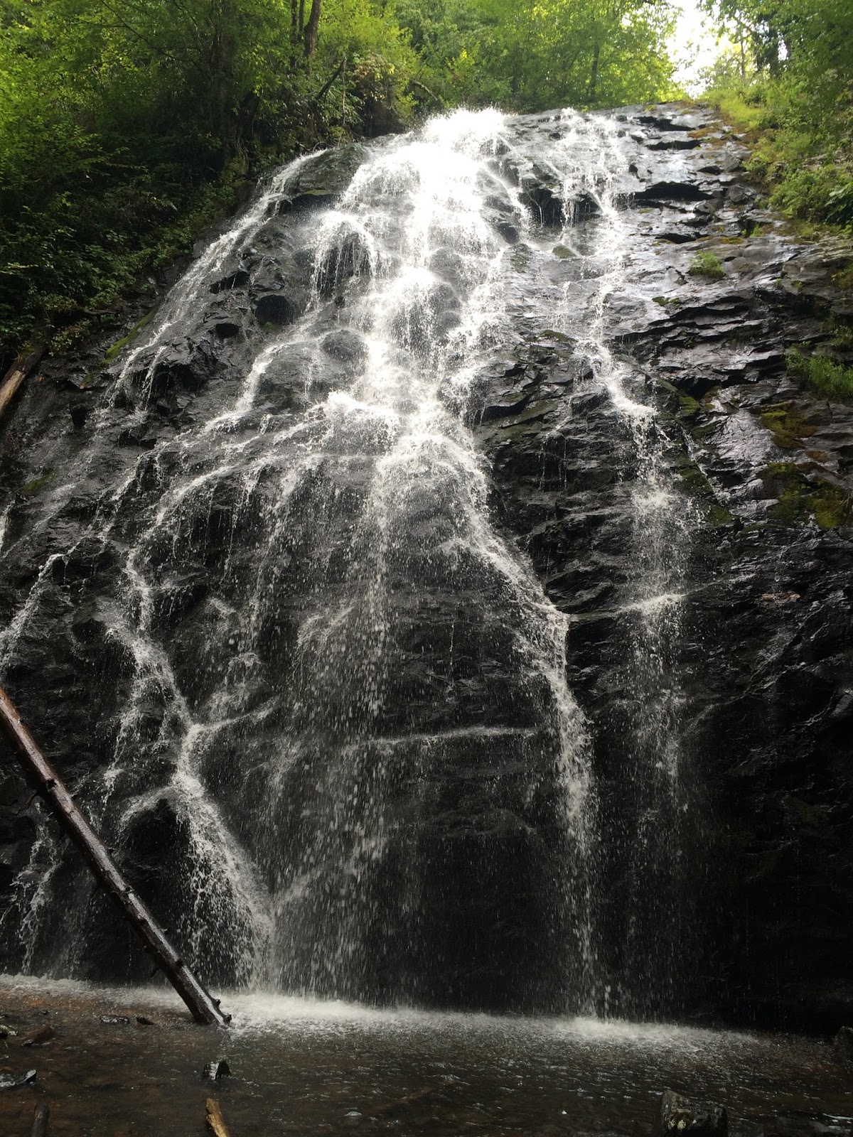
With great difficulty we left the visitor center behind us and drove to the Rainbow falls trailhead which is about another 1 mile to the south. The trail is very well marked and fairly easy. There are several spurs along the trail to access the creek if you want to play in the water or just get your feet wet. It took us about 40 min to reach the overlook to rainbow falls. There is a flight of steps just before the overlook. It is not that you don’t know that you are getting close to the waterfall as the thundering sound of the fall keeps getting closer, but once you climb the steps the fall suddenly reveals itself and just blows your mind. The fall is spectacular and was worth resisting the temptation to just enjoy at the visitor center. It has great force and a significant volume of water gushing through it into the swimming hole below. There are several overlooks to look at the falls from the front, below and top. The one I liked best was the overlook about midway on the spur trail that leads to the bottom of the falls from the main trail. I will advise to be watchful while descending though since we accidently disturbed a swarm of bees on our way down and got stung pretty badly.The swimming hole itself is a perfect spot for swimmers of all kinds. There is a nice swimming area as well as several places to dive including some not-so-safe but really exciting places if you like. It is possible to continue on the main trail further to get a top view of the falls and then reach turtle back falls. We decided to pass on turtle back falls since we had decided to see some other falls in the area. I would rate the hike easy to moderate and pretty much doable for anyone who can walk.

After having a nice lunch at the visitor center enjoying the mountain views as the sky had cleared up, we left for Whitewater falls. Whitewater falls is 8 miles south of Gorges state park in the Nantahala national forest. The trail to the overlook is a short ¼ mile accessible wooden walkway. There is also an option to go down via a flight of steps to have a closer look at the falls. From the overlook at the end of the stairs the upper as well as lower falls are visible, so I would certainly recommend the descent. There are no fall views past this point although one can continue on the trail to access the foothills trail. We enjoyed the view at the lower overlook and trekked back to our cars. I can imagine this being a very nice place to view fall colours.

Our next plan was to visit some falls along Highway 64 / Highlands Rd near Highlands NC. The first fall we saw was Bridal Veil Falls which is a small stream of water falling from the cliff hanging over the road. One can drive behind the falls using the small pullout. After a brief stop for pictures we proceeded to Dry Falls which is just 5 mins away from Bridal Falls on westbound Highway 64. Dry falls can be seen from an accessible wooden pathway leading to an overlook. Alternatively the falls can be reached via a wooden walkway and a few stairs. This is a fantastic place for taking some nice waterfall pictures. The waterfall has a significant drop and here you can walk behind the falls through a small recess in the bluff secured by a wooden fencing. Our visit to the fall was abruptly cut short by the sudden showers that showed up and drenched us in the approximately 5 mins that it took for us to reach our car. This is a must visit place and if you are anywhere in the area I would certainly recommend taking a detour to visit Dry Falls.

On our way back we decided to take a different northbound route so that we ended up driving the complete loop around Southern Section of Pisgah National forest to reach Asheville. This also allowed us to make a brief stop at Cullasaja Falls on Highway 64 which is a nice fall nestled in the Cullasaja river gorge. This one is easy to miss though since there is only one overlook and it is not marked at all. You really have to keep looking to find the overlook. This completed 5 waterfalls for us for the day. After a long day we were in the mood for some comfort food and the consensus in the car was for Italian. So we decided to stop by an Italian place called Favilla’s New York Pizza as recommended by Yelp. Although the reviews for the place were good we were a little circumspect as the place itself looked pretty run down and the neighborhood looked a little sketchy. Regardless in the interest of time and hunger we decided to try it out. I must say I was impressed by the food which justified all the good reviews. We got garlic bread and a customized New York style pizza. The Garlic bread was good and the pizza was delicious although a little too greasy for those health Nazis out there. I am not complaining though because it is my opinion that what good is a pizza if it is not greasy. This was a fitting conclusion to a day well spent exploring a few of the several beautiful waterfalls in the area. 5 down, many to go.


Saturday, August 22, 2015

Backbone Rock and Blue Hole Falls - 22nd August 2015

Backbone Rock recreation area is in the northern section of Cherokee National forest. The area can be reached via Shady Valley TN. From Johnson City we took the Bristol highway US 11E-N then TN-394E followed by US-421S to reach Shady Valley. In Shady Valley we took TN-133 N to Damascus for about 9 miles to reach the Backbone Rock recreation area. The drive through Shady valley is beautiful offering a winding road through the lush green Cherokee National Forest followed by scenic views of the valley complete with green grasslands, tiny flowers of all hues and colours. Once we reached Shady Valley we took a left turn on TN-133 N at the famous Shady Valley Grocery store. This store apparently is a rage among bikers and so is the winding road in the valley. The store proudly claims that it is "Home of the snake - 1 Valley - 3 mountains - 489 curves" (The snake being a 33 mile winding road which has 489 curves spanning 3 mountains perfect for bikers to enjoy their beasts). This is indeed a biker's paradise and as expected we saw plenty of bikers enjoying the scenic road and the perfect weather for biking.

The backbone recreation area is a typical quiet area you would see in a national forest complete with picnic tables, campground, a small amphitheatre and a nice stream passing along the main attraction the - Tunnel. The tunnel is a nice spot for pictures. Essentially it is the centerpiece of the beautiful recreational area which has something to offer for everyone. There are two trails which start on the Shady Valley side of the tunnel. Backbone rock falls trail,  a 0.4 mile loop trail, which is rated as strenuous due to steep drop offs and altitude gain over a short hike starts on the right side of the road . We did not hike this trail (maybe next time). The other trail starts from the parking lot on the left side of the road and takes you to the top of the tunnel via a flight of steps. This is really not a trail but mostly a climb up the stairs to gain beautiful view of the dense forest around and the road below. The climb is fairly simple 5 min climb as long as you are comfortable climbing steps. I can imagine this to be a perfect fall colours viewing spot.


After we left the area we stopped on our way back at the Country store in Shady valley to enjoy some ice cream and fries. This is the quintessential biker store complete with leather jackets and all kinds of biker accessories for sale. It was their anniversary and they were giving away frosted cupcakes so we enjoyed a couple of those as well. Then we decided to take the other route via TN-91 S to reach Blue Hole falls on our way back home. Blue hole falls is located on panhandle road off of TN-91 S. Driving southbound we took a right turn on Panhandle Road / Forest road 202 to reach Blue Hole parking area in about 1 mile. The hike to the falls is about quarter of a mile, if that. The falls are pretty and have a nice swimming hole. The fall is broken into 4 sections with the swimming hole being under the second section. There are opportunities to dive in the hole from a couple of trees and boulders above the hole. The water is at least 8-10 feet deep so one can safely dive from a modest height as long as you avoid the shallow rocks on the edges of the pool. This is also a great spot for taking some nice waterfall pictures. 


We left the falls after spending some time taking pictures and resisting the temptation to take a dip in the nice cool swimming hole and returned home via Elizabethton. The trip had all elements of enjoyment - a nice drive, a short hike to an overlook, a quick pitstop at a local place for ice cream and a pretty swimming hole with waterfall. One can surely make a daytrip out of this route.


Friday, August 21, 2015

Craggy Gardens, Blue Ridge parkway and Asheville - 21st August 2015

Having the Blue Ridge parkway so close is such a convenience. It is just so easy to go for a drive, stop by at a nice overlook and make a day out of it with a nice dinner along the many pretty towns dotting the parkway. That is exactly what we did last weekend. We started from Johnson City around 2 pm and drove to Blue Ridge Parkway via Asheville. As always the drive along the parkway itself was a delight and the one and half hour that it took for us to reach the trailhead was very enjoyable. 

There are two places where one can access the Craggy Garden trail. Driving northbound from Asheville you will see a turn on the left for the picnic area. This is a short drive up the mountain to the parking lot. If you continue on the parkway instead of taking the left you would reach the visitor center in 3 miles. We parked at the picnic area and started the trail from there. The picnic area has quite a few picnic tables and a restroom. The trail from picnic area to the visitor center is about 0.8 miles. About halfway into the trail we reached a Shelter where we met a chatty couple (for the most part the wife being chatty and the husband trying to get going). There is a spur that goes on the right side of the shelter when approaching from the picnic area which appears like the trail, but it is not. The aforementioned chatty couple said that there was not much of a view along that spur so we just decided to continue on the trail past the shelter. The visitor center is probably a 5-7 min hike from the shelter. The trail is in a very good shape, with green tunnels and nice wildflowers all along the trail.


The visitor center is very pretty with scenic views all around. For first timers I would certainly recommend starting the trail from the Visitor center access. One can also see a nice view of the Craggy Pinnacle from the visitor center. We had a little picnic by the visitor center while enjoying the great view all around. I can imagine this to be a very nice spot for watching sunset. It would be even better to watch it from the Craggy pinnacle which is a 1.4 mile hike up the mountain. The trail head for Craggy Pinnacle is just another mile or so northbound on Blue Ridge Parkway past the tunnel. We decided to do that some other day.


We then drove back to Asheville, about a 20 min drive, for dinner. We decided to spend some time strolling downtown since we were still early for dinner. The Asheville urban trail is a good way to explore downtown if you have some free time. It is not so much of trail but a walk around the town appreciating the hipster ambience  and the interesting street art installed along the way. We were also treated to quite a few road performers playing country music along the walkways. Asheville has a very energetic appearance to it and the myriad restaurants/food joint lacing the streets and bursting at seams with patron add to the appeal. We stopped for dinner at a Mediterranean place called Jerusalem Cafe which does not have much to talk about. The food was good but not great, the ambience even more uninspiring and I really don't like to talk much about a mediterranean place if their Hummus and Baklava are both not out of the ordinary. (But then again we are spoilt by the good Mediterranean we have had elsewhere - Charleston?).

In summary Craggy Gardens is definitely recommended if you are looking for fantastic views, a short hike, beautiful sunset and a drive around the parkway.

Friday, August 14, 2015

Crabtree Falls - Pisgah National forest 14th August 2015

Crabtree falls is a waterfall in the Pisgah National forest along Blue Ridge parkway. It is located in the Crabtree Falls & Meadows recreation area at milepost 339.5 of Blue Ridge parkway. The recreation area is pretty big with a visitor center, amphitheatre and pretty nice campground. The trailhead is at the visitor center and passes along the amphitheatre, campground registration station and the campground before delving into the woods. About quarter 500-600 yards into the trail we encountered two stairways. The trail is very nice and quite and not very difficult. There is a fair bit of elevation loss around 700-800 feet but it is not strenuous. The hike to the fall is about 2.5 miles roundtrip. there is also an option to continue hiking past the falls to complete the loop to the parking lot, the mileage being about 3.5 miles for the loop. The falls are pretty and if you are so inclined you can get wet standing under the falls or just get your feet wet in the small puddle generated by the falls. There is a small footbridge right in front of the falls which is a perfect spot for picture. The hike is fairly easy, the only difficulty could be the rocks on the trail which could be slippery on a wetter day. It took us around 45 mins to reach the falls at a very relaxing pace. I was back in 25 mins as I scrambled back to keep my camera from getting wet due to the rain that showed up suddenly. In summary this is a nice 2-3 mile hike if you are looking for a quick hike along the parkway. Based on your speed and inclination the hike can be completed within 2-3 hours including ample time at the waterfall.


Sunday, August 9, 2015

South Holston Dam and Osceola Island Recreation Area - 9th August 2015


        After a lazy weekend we were considering a hike close to our place which would be accessible to our 80+ year old grandparents. Since we had not come up with a place and it was almost 6 pm on a Sunday the chances that we were going anywhere were almost slim to none, almost like we were delaying the decision to the point where it ceases to be an option. Suddenly South Holston Dam came to mind as a potential spot since it is a 35 min drive from Johnson City and seemed like a good place if you are in the mood for a leisurely walk. Also it helps that the days are long at this time of the year and you can consider getting out even so late in the day. 
       The drive to the dam took us exactly 40 mins via US-11E N and the TN-394 E . Once you turn right on Emmett road and then Holston View Dam road, the dam can be seen almost continuously. The scenery is refreshing. We decided to drive past Osceola Island and first check out the top of the dam. As we reached the dam we were just so happy that we decided to come, as the rewards outside the window were just beautiful. We parked at the end of the Bridge across the dam and then walked over the dam. The view of the South Holston lake, the dam, the South Holston river below and the lush green mountains around was breathtaking. Since it was close to sunset there was a festival of colours bursting in the sky. The water released from the dam into the river had formed a cover of mist over itself adding to the beauty of the scene. We spent some time just strolling along the dam and taking pictures. It was a picture perfect sunset indeed and it was difficult to pass on the opportunity to watch the sunset from the dam. But we decided to pass and drive down to the Osceola island recreation area to check it out. The recreation area did not disappoint us too. The parking lot is right besides the river and a bridge to the island. The water looked even more beautiful from up close. The mist cover over the water gave the whole area a mystical feel. The biggest attraction though was the weir dam. A weir dam is essentially a construction of series of structures in a way that they hold the water behind them but also allow it to flow over them (my theory mostly the outlet flow is less than the inlet flow, hence the pooling - sorry but couldn't help putting my engineering hat on :P ). The dam creates a very beautiful flow pattern which is a photographer's gold mine. I just couldn't stop admiring how beautiful this place was and so close from where we live. I took a zillion pictures and then when the lens was tired and yet couldn't capture the beauty that the eye could discern, we just stood on the bridge admiring the beauty of nature unfolding in front of us.
     We decided not to do the 2 mile hiking loop on the island in the interest of time so that we could have a reason to come back to this place (not that we need one). We devoured the nice little dinner that we had packed at the best picnic table there is in the area right besides the river and returned home knowing well that we were going to go back soon enough.

Update 12th August: 

As I had anticipated we did actually end up visiting again just in the space of few days. This time it was a brighter time of the day and we got to see a different view of the weir dams than the fog covered view earlier. We also walked the roughly 2 mile loop around the lake. It is a nice leisurely walk along the river and can be done by people of all ages. The gentle sound of the water flowing by is very relaxing. We were lucky enough to see a paddling of ducks show up on the river. And sure enough the fog showed up as the evening got cooler.


Sunday, August 2, 2015

Devils fork trail - August 1st 2015

A trail blog after a long time. I have been meaning to start writing a travelogue for our escapades for a long time. It has been more than once that I have said to myself "OK, this is it, today when I get home after this trail I am going to start writing". Finally I have gotten around to doing it today. Hopefully I will be more persistent from now on.

Devil's fork trail was suggested by one of our friends. I had never heard about it so we googled it. The pictures seemed cool and the trail description enticed me as it mentioned several stream crossings. We were undecided till almost 11 am. Finally we decided to go and since it was just an hour's drive from Johnson City we thought we still had a good shot at the 7 mile loop trail. The drive from Johnson City to the trail was pretty with the panoramic landscape that we have gotten used to staying in this part of the country. We took I-26W and the US-23N towards Gate City, then got onto VA-72N towards Fort Blackmore  via VA-71N (E Jackson Street), turned left on State Rt 619 (Big Stoney Creek Road) which becomes High Knob Road and then finally turned on Forest Road 619 which ends at the Devil's fork trail head. As we approached the final dirt road towards the trail head parking we met a guy coming back who was kind enough to inform us that the parking was full at the trail head and so we were better off parking at the roadside and just hike in the last 0.4 miles which was the dirt road. For hikers planning to visit a useful tip is, it is OK to park along the road on the left side (along the stream) if the trail head parking is full. There are "no parking" signs on the right side of the road since this is private property. From what we saw this trail seems to get REALLY crowded during weekends.

As we parked we were still in two minds considering wether we should do the entire loop or just hike to the Devil's bathtub and back since it was already 2 pm. Finally after consultation with a friendly couple who had been on the trail before and were considering doing the loop too we decided to hike the full loop. So we started the hike at around 2.10 pm. The hike to the trailhead is not much and took us 5 mins, if that. There is a clear sign that directs you to the trailhead. As we were just about to start the trail we saw a family coming back from the trail and getting frustrated because people had parked cars all around their car so that it was impossible for them to get out. Poor guys, I hope they got out soon, people really need to be more considerate while parking in such tight spots. The trail-head is actually past the steel gate. After we passed the gate there was a sign which indicated the two directions in which the fork trail went.

We decided that we will complete the loop from west to east since that way we would complete most of the hike before we reach the Devil's bathtub for a dip. The trail was very well marked to our surprise since a lot of reviews we read mentioned that it was not well marked and was confusing at times. I think somebody has done a very good job at marking the trail blazes very recently as the yellow blaze is hard to miss as long as you are not paying attention at all. There are a few fallen trees along the first 1 - 1.5 miles of the trail which obscure the trail briefly so be careful to not be deterred by those. It is an easy scramble across the trees and the trail is pretty prominent after every fallen tree. This section of the trail can be strenuous for some, since it is pretty steep, almost a steady climb of around 900-1000 feet. About 1.5 miles in the trail we reached a fork where the Devil's Fork trail continued eastward and there was a spur for Straight fork ridge trail. The hike from here on is fairly easy. We encountered about 3 stream crossings till we reached Devil's bathtub from this side. The trail itself is very rewarding with a lot of green tunnels, tiny creeks and the occasional water holes on the way. We saw a pretty fall with a water hole just 0.5 miles before reaching the bath-tub.


The bath tub itself was refreshing. We reached the around 6 pm and so a lot of the crowds had left although there were still around 20 people hanging out. I am glad we decided to complete the loop first as I can only imagine how busy this place would have been in the afternoon. We spent around an hour in the area taking pictures, jumping in the tub and just looking around. The whole area is really pretty with the bath being the central attraction and 2-3 other waterhole around it. Personally I felt that the bathtub was a nice place to take a dip but if you wanted to swim or at least float around the other two swimming areas further down the trail are better. It is overall a nice area to hangout and one can easily make a picnic out of it just hiking the east side to the trail to the bath-tub. 

The trail back was short, albeit with several stream crossings. I had decided to count but lost count. I would agree with the general consensus that there were about 12 stream crossings, none of them really challenging and my feet got wet just once and that too probably because of my own clumsiness. I can imagine these crossings could be a little more tricky if there was much more water than there was today. It took us about 45 mins to hike from the bath tub to our car and we took our time enjoying the trail. The trail mileage was around 9 miles including the extra 0.5 miles hike from our car to the trail head. My assessment is, a normal hiker can complete this loop in 5 hours including ample time at the swimming holes. 


We also ended up making friends and exchanging contacts with the friendly couple we met at the start since they were with us for the most part. My respect for them increased immensely after I noticed that they had packed out a bag full of trash left by other visitors on their way out. Another unfortunate outcome of a trail being easily accessible to not-so-considerate people who like to be jerks on the trail.

Overall I think this is a very rewarding trail considering the proximity and accessibility from the tricities area. Definitely a must do if you live in the area. Check the following link for the gpx for the trail and the trail map.


- Koustubh