Friday, October 9, 2015

Fall Creek Falls State Park - 9th October 2015

Fall Creek Falls State Park is located in southeast Tennessee and from what I hear it is one of the most visited state parks in Tennessee. It is home to Fall creek falls (from which it derives its name), Rock house falls, Cane creek falls and Piney creek falls. It also has a nice lake, like a real lake, not the one you would have in a landscaped community and the park is rightfully called Fall Creek Falls state resort park as it offers an abundance of activities for visitors of all tastes ranging from the hard core hikers to families wanting to just have a relaxed time in a beautiful natural setting.

We had planned the trip here last weekend but postponed it since the weather turned really bad with torrential rains lashing the south and southeast. Yes this was the same weekend when hurricane Joaquin was supposed to hit and when South Carolina got drenched, flooded or whatever term you would like, with unprecedented rain. Anyways long story short we postponed the trip last week and this week decided to head out hoping for better weather as promised by the good guys at weather.com. We left Johnson city on Friday afternoon and reached the park little around 10 pm after making a stop in Knoxville for some errands and a quick dinner. Well, it appears our friends at weather.com had quietly reneged on their promise of good weather and while we were driving updated the weather to indicate thunderstorms tonight continuing into Saturday and we were greeted by rain just as we headed into the park. It took us some time to find the campground and when we finally did it was not at all an enticing proposition to set up camp. In the interest of keeping ourselves and our gear dry we decided it was not worth setting up camp and hence decided to sleep in the car itself.

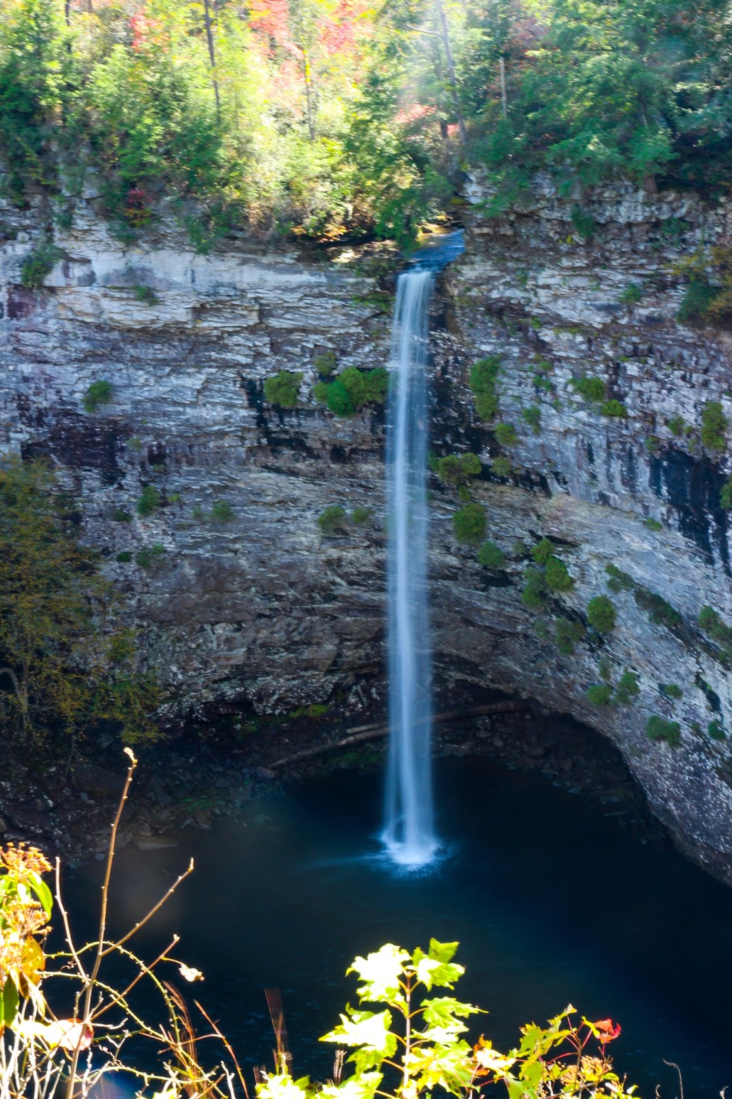
We got up at around 8.30 am and not surprisingly were greeted by rain and some chilly  weather. We decided to at least go for a drive around the park to get a sense of the park and then grab a bite at the inn. As we drove around we stumbled upon the scenic loop drive, and as that appeared to be as good a option as any, embarked on the drive. Within short drive is the overlook to fall creek falls. I must say one look at the falls and we stopped complaining about the weather. Yes the weather was muggy, yes we couldn't hike, yes it was cold and yes the fall was not anywhere close to its full strength. But was the view beautiful? Absolutely yes. The fall was sliding down the bluffs silently into the small pool below. The surrounding forest had turned to a medley of colors dominated by greens but accentuated by bright reds and yellows. These are the type of fall colors that I sometimes appreciate even more than bright orange yellow blaze at the peak of the fall. I really like the contrast the nice relaxing green provides to the bright reds and yellows. The fog was just rolling across the forest intermittently hiding and exposing its beauty. The view was serene and the cold weather had kept all the tourists out. We had this fantastic ambience just for ourselves with not a single sound apart from that of the forest. 

After devouring the solitude and the beautiful view we drove to Piney falls along the loop. The outlook on the right side of the parking lot, about a 2 minute hike, provides gorgeous views of the falls. This fall is in great contrast to the fall creek falls we saw earlier. It was gushing with a huge volume of water, very powerful with it's thunder echoing in the gorge. The view was spectacular with the forest ablaze in oranges all around and a nearby red tree providing the perfect frame for a photograph of the falls. We spent almost 20 minutes marveling the beauty of the falls and decided that we might want to consider coming back later in the weekend to see these falls again. Then we headed towards the inn to get some hot breakfast. The inn is a nice place located on the lake and the restaurant has nice views of the park. The menu is standard southern breakfast with a pretty good buffet. We just got a nice omelette and a coffee while mulling over what to do next. 

The rain had eased of by the time we finished our breakfast and that certainly lifted our spirits. We drove to the nature center to check it out. While at the nature center, we looked at the cane creek falls and rock house falls from the overlook right across the centre. This overlook provides a nice view of the falls but I wouldn't say that this is the best place to view the falls. We also watched a small movie about the park which is played on demand in the nature center. The lady at the center was having a really rough day I must say, as it was her first day on the job and she had a hard time figuring out the credit card machine, while answering people's question and attempting to also sell some trinkets. We then walked to the bottom of the cascades to get a nice view of the falls.

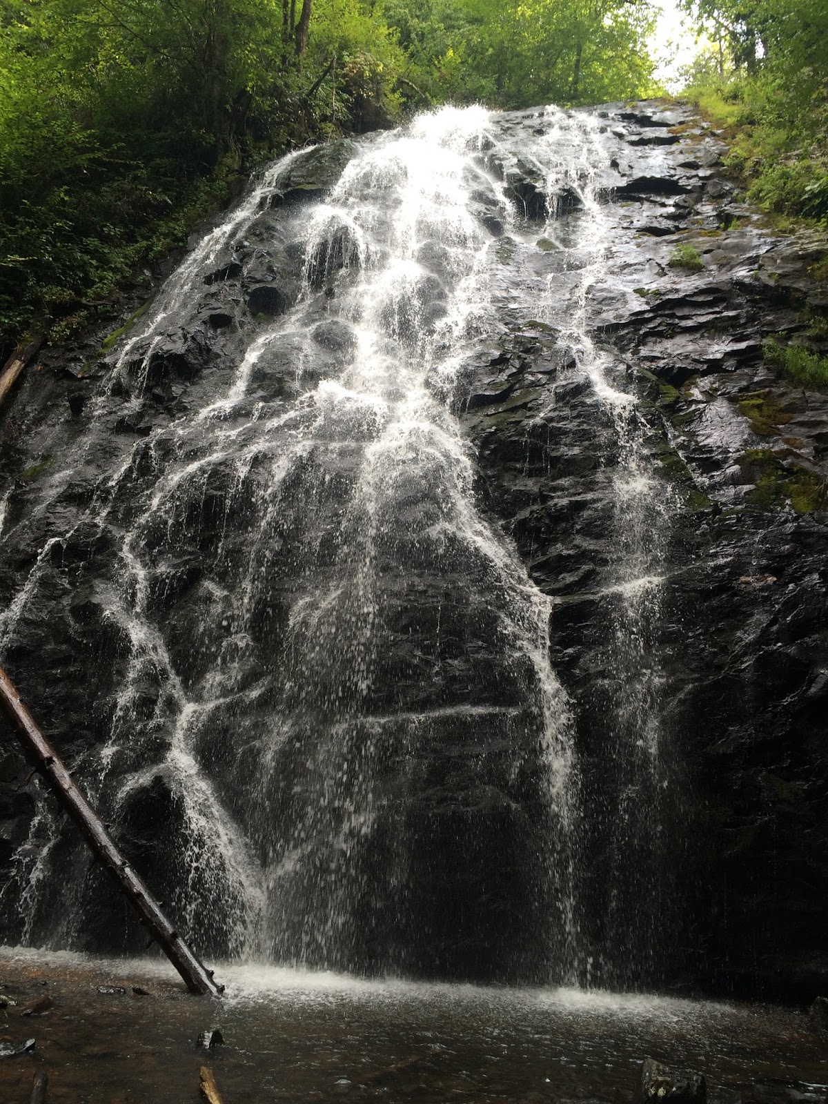
I then decided to take the small but adventurous cable trail to the bottom of cane creek falls. The hike is a really short hike and probably takes 10-15 minutes to reach the bottom of the falls. It is a vertical hike for sure and has some awkward spots. The section of rocks almost immediately after the point where the cable starts is the trickiest one. If you can negotiate that then the rest of the hike is pretty easy. Having said that I will say that the hike isn't as ominous as the name suggests. There is a cable overhanging along the hike but you really do not need to hold the cable or climb down hanging by the cable. There were probably 1-2 points where the cable really helped but the rest of the trail is pretty much scrambling across rocks. The view of the falls at the end of the trail is gorgeous. You can see the cane creek falls falling in the beautiful pool below with the rock house falls as a companion on the left side. To get a really nice view I walked downstream and crossed the stream to a point from where I could see both the falls and the pool below. Without doubt this is one of the best picture spots in the parks he best view of the falls together.


I finished the quick hike back to the car and we decided that we could also complete the paw paw loop trail. The paw paw trail is a 2.6 mile loop trail which provides nice views of the cane creek gorge as well as an overlook to look at fall creek falls. We could barely see the falls from the overlook as the water flow was really low but the hike is definitely worthwhile as a nice walk in the woods. This is a very easy hike which can be done by pretty much anyone who is in a reasonable shape. We finished the hike by around 4.30 pm.

The weather had gotten really nice by this time and we decided that we could still do the Gilbert Gaul loop trail around the lake and makeup for some lost hiking time earlier in the day. The loop is a 4.4 mile hike and the trailhead is just before group campground 2. The first half of the trail is pretty much a walk in the forest with a pretty flat profile and you pass a nice clearing along it. We reached the lake just after the sun had set and we could still see the sunset colors and those of the surrounding trees glistening in the lake water. Our appreciation for the beautiful views was short lived though because soon enough the concern about the reducing visibility overshadowed the beauty of the view. We hastily started hiking on hoping that we could finish the hike before it became completely dark. I must mention that this trail is very poorly marked with absolutely no blaze and probably only 2 or 3 signposts at locations where you almost cannot see the trail at all. The second half of the trail is terrible in terms of marking with absolutely no markers. Your only guide is the faint outline of the trail which you will most likely miss if you don't pay attention. Also it did not help our cause that we miscalculated the time that the trail would take and did not factor in the fact that the park is in central time zone as opposed to eastern time zone just few miles to the east and hence the sunset would be at an earlier time. The result of all this was that by the time it got completely dark we were still on the trail and were freaking out. Fortunately we had our cellphones and this part has full network coverage so I could constantly keep an eye on the gps. We decided to just keep the lake on our right and keep walking as we knew that we would eventually reach the inn that was on the lake. The gps indicated that there was a fork by the lake almost 3 miles into the loop where we were supposed to take a left and I swear we were right at the fork and could not find it. Finally as we could still not see the inn and it had gotten completely dark with our batteries at 40% we decided it was wise to call 911 before we ran out of batteries. The gentleman on the line was pretty helpful and while I was talking to him we saw the lights for the inn in front of us. That made me feel really relieved and I was sure we were safe. The 911 dispatcher still sent over a park ranger to come get us  to be safe and the park ranger dropped us off at our car. The ranger did agree that the trail is poorly marked. I think I will completely take the blame though for the mishap since we could have planned better to avoid all the drama. 

Anyways with all the drama behind us and the weather improved significantly we headed to our campsite, set up our tent and made some hot dinner from the food we had packed taking advantage of the electrical hookups available at the site. Considering the muggy start we had to the day, I must say the day turned out to be fantastic and in fact, save the drama towards the end, couldn't have been better.

The next day was all about tying up loose ends and visiting spots that we had not visited. We hiked the trail to the bottom of fall creek falls which is on the right side of the parking lot. This is probably a 1.5 mile in and out trail which is mostly a steep hike. The view from below is nice and the are quite few rocks below where you can hangout. After this trail we did the suspension bridge trail and the loop after it. The suspension bridge is pretty and gives a nice view of the creek just before it falls down the cascades. As you proceed on the loop there is a nice overlook on the right which provides a front view of rock house falls and cane creek falls. I would rate this as the second best view of the falls in the park. The trail then just continues along the gorge with a couple of overlooks along the way. We completed the loop to come back to the suspension bridge. There was quite the line to get across the bridge this time around as it is recommended that only six people cross the bridge at one time and there were several people waiting to cross. We then drove over to piney falls and visited the suspension bridge there. To be frank this was not as exciting as the overlook from where you can actually see the full piney falls. There is one overlook on the way where you get a sneak peek of the fall and then the bridge itself hangs over the overflow of the falls. 


With almost all attractions in the park checked off our list we decided to head back and see if we could take a stab at ozone falls on the way back. When you search for ozone falls, google maps will directly you to Cumberland Mountain state park. So we followed the lead. When we reached the park it was almost 6 pm and getting very close to sunset. The park has a nice restaurant overlooking the lake and arch bridge. We decided to settle down for dinner, particularly after we found out that ozone falls is actually 20 mins away from the park and we couldn't make it in time anyways even if we left right away. We had a nice quite dinner appreciating the beautiful view of the bridge and the colorful trees reflected in the lake. We then headed back home savoring the memories we created this weekend, getting ready to face another work week before the next hike. Fall creek falls state park is a very impressive park with great scenery and 4 gorgeous waterfalls. A must visit and certainly worth spending the complete weekend

Monday, September 7, 2015

Acadia National Park and Boston

3 Sept 2015

Our first trip to Maine. Really excited. The proposed itinerary is dinner with Family in Boston today evening, Acadia National Park from Friday to Sunday, explore Boston on Monday and return home early morning Tuesday. Let us see how well we stick to our itinerary (we have almost always improvised)

19 th September 2015

So finally managed to sit down to write this trip up. This has been a busy month. 

Day 1 - Friday 4th September

The dinner at Carlisle (a suburb of Boston ) was a nice family affair. We left from Carlisle to pick up our friends at Boston Logan airport. The drive back was a breeze compared to the traffic jam that we endured earlier that evening to get out of Boston. We stocked up on some food and beverages since we were planning to drive through the night and have breakfast atop Cadillac Mountain at sunrise. We had rented a Dodge Durango and I was pleasantly surprised at how big the vehicle was and pretty powerful too. The drive from Boston to Acadia was uneventful (particularly for me since I made good use of the spacious luggage space to catch some sleep). Since we left the airport a little later than we would have liked to we were racing against time to catch the sunrise. By the time we reached Trenton we were still 30 mins away from Cadillac mountain and the sun had already started to rise, so we decided to stop at one of the nice overlook along the the Desert Narrows to watch the sunrise. It was a beautiful sunrise with the water glistening in gold and clouds shaded in purple. The air was a little nippy and reminded that some of us who did not have a jacket needed to get one asap.
After spending almost 30 mins watching the sunrise we made our way to the nearest Walmart and shopped a little bit for necessities. Since it was the perfect time for breakfast and we had not reached Cadillac mountain in time for sunrise anyways, we decided to have a proper breakfast at Bar Harbor. A quick yelp search directed us to Jeannies Great Maine Breakfast. Since it was still Friday and the labor day weekend crowds had not rolled in just yet , downtown Bar Harbor was pretty quiet and we could easily find a parking spot right across the restaurant.  The breakfast was fast and delicious, more so since we were hungry after an overnight drive. We gobbled down the food discussing what our plan for the day should be. We quickly decided to hike the Dorr Mountain Ladder trail so that we could get a feel of the area and prep ourselves for perhaps a little more challenging hike for the next day. 

The Dorr Mountain trail was pretty relaxed and we encountered the much talked about iron rungs only twice on the trail hiking via the ladder trail. It is a nice trail with pretty views of the ocean all along. I couldn't believe how blue the Ocean looked and the light was just perfect for taking pictures  without getting a lot of glare from the ocean which usually spoils the picture.It is just about 1000 feet elevation gain and I would consider this trail as moderate difficulty, if that. We reached the summit of Dorr Mountain in about 1 hour at a very leisurely pace. We spent some time soaking in the views and taking pictures. There is an option to continue the trail to reach the summit of Cadillac Mountain but we did not pursue that since we were anyways planning to drive up to the summit. The descend was quicker and we were done with the trail by 12.30 pm. Since we still had almost half a day left we decided to explore the Jordan Pond area before proceeding to the beach.

Dorr Mountain Ladder trail
Summit of Dorr Mountain


Driving towards Jordan pond we saw the parking area for the Bubble rock trail access. Since it was pretty crowded we decided to stop and check it out. We hiked the short trail to access bubble rock which is a huge rock precariously balanced on the ledge, apparently deposited in place by Glaciers back in the time. This point has a very nice overview of Eagle lake. As usual people were trying to do stupid things at the rock while I was contemplating what would happen if the rock was indeed displaced by the pressure applied by people leaning and trying to pretend they were pushing the rock. On our way back we missed a fork and by a happy coincidence found out that there is another trail that leads down to Jordan pond and has a fantastic overlook of Jordan pond and the ocean in the background. The overlook is just steps away from the fork to the trail back to Bubble rock parking lot. Later we drove to Jordan pond which is just a mile or so further south. We walked along the pond trail for a little bit looking at the reflection of the famous bubbles and dipped our feet in the pond for a little bit. There were quite a few ripples on the lake so couldn't actually capture the reflection of the bubbles. This is a nice leisurely stroll. Then we returned to the Jordan Pond Tea house to have some popovers and finger food.
Balance Rock
Jordan Pond from South Bubble
North and South Bubble in Jordan Pond


To end the day we drove around the ocean side of the park on the road parallel to the ocean path. Initially we had decided to hike the ocean path but after the long day we decided that we will take the easier way out and just stop at viewpoints on the way. We made stops at the sand beach, thunder hole and tinker cliffs viewpoint. The beach is pretty and very picturesque with  a nice contrast provide by the red rocks to the blue water. The thunder hole kind of disappointed us since the ocean was pretty calm and hence we did not get to see the thunderous waves that it is known for. By the end of the day we were so exhausted that we ended up skipping dinner and just heading out to the hotel to have some of the food we had packed.The Day's Inn we were staying at is a pretty nice location, just minutes away from Bar Harbor and right by the ocean. The rooms are standard and good value for money. We turned in at around 9.30 after a hectic day determined to wake up early in the morning to catch the sunrise at Cadillac Mountain next day (I know, pretty early by trip standards even for that)

Day 2 - Saturday 5th September

The next day started with a beautiful sunrise which was viewed from the summit of Cadillac mountain by a lot of people while we were bundled up in our beds. The closest we got to watching the sunrise was when we saw the glimpses of the fleeting sunrise hues over the ocean from our hotel window. Our hungry stomach pretty much dictated the agenda for the morning and we were invariably drawn to quaint downtown Bar Harbor for breakfast. Today was a different story altogether. The downtown was packed with tourists who had come in the previous night, parking was hard to find and all the businesses were bustling with activity. We managed to find a table at 2 Cats breakfast restaurant, another gem of a place. It was vibrant with the chatter of tourists, servers rushing to fill empty coffee cups and a generally happy air all around. The food was again good and I noted that the Jalapenos here are good with a kick (I had noticed the same thing the day earlier at Breakfast when I got my veggie omelet loaded with Jalapenos). With our tummies full and spirits lifted with some earthy coffee we decided to take on the Precipice Trail, one of the crown jewels of the park.
The trail starts with ominous warnings about its strenuousness and historical fatalities. It doesn't waste time in getting into a vertical climb. We were greeted by some iron rungs about 5 minutes into the trail. These rungs are not too bad but a good test of your ability to continue the trail further. If you are not able to climb these then this is a good time to turn back as the trail has several of these and similar scrambles ahead.  The trail is pretty well marked with blue blazes on the rocks / trees. Immediately after the first set of rungs you run into a short boulder field, which reminded me of the boulder fields at St Helen's, although this one was much shorter and not so challenging. We missed the trail briefly and ended up climbing the whole boulder field instead of taking the short turnaround which circumvents the boulder field to continue on the trail. This probably added around 10 mins to our hike, so that should give you the idea about the size of the field. The trail gets progressively better in terms of views as you climb higher and higher.  It is pretty well maintained and if you are comfortable climbing iron rungs then I must say that there are very few places where there is any serious chance of you getting hurt or killed unless you are acting really stupid. I thought there was just one point on the entire trail where it could be safer if there were a couple of support bars but other than that I think the trail was thrilling without serious dangers. The junction where the orange and black path meets the precipice trail is a good spot to relax, take some pictures and get ready for the final climb.
Precipice Trail
Junction of Precipice Trail / Orange - Black path
Precipice trail
Once you reach the top the views are spectacular and the sense of accomplishment you get after completing the trail make them even more beautiful. You can see the lush green park  below, the vast expanse of the blue ocean dotted with the several islands and sailboats which offers a nice panoramic perspective. We spent a lot of time admiring the views, taking weird pics (you kind of have to right?) and snacking. It was only after we had spent considerable time that we realized that we were not at the summit yet and there was still some distance to be covered. The distance is not much though and the trail is all flat from here on, save the final set of baby iron rungs just before the summit. The summit is marked by a trail post which indicates the several trails intersecting here and makes for a nice picture spot. We descended by the Champlain N Ridge trail and followed the Orange and Black Path to the road savouring the views and feeling great about having completed the trail. 

We decided to give the thunder hole a second chance today to impress us so we drove by the ocean path again. We were disappointed again by the calm ocean but the place was way more busy than yesterday, swamped with tourists. We managed to find a high perch just besides the thunder hole to relax and appreciate the beautiful colors in the sky and feel the air, a perfect spot to power down. Then we walked the ocean path a little to reach the pebble beach or as they like to call it the monument cove, a spot that we had missed yesterday. The trail is very pretty with a canopy of trees covering it. After spending the evening along the ocean it was time to head out to downtown Bar Harbor to enjoy a nice cold beer. This was again a different town altogether. Bar Harbor was lit up with music playing out of the bars and on the streets, trinket shops filled with tourists, cocktail glasses clinking in the restaurants, all in the backdrop of a sky on fire with the sunset colors. We managed to snag what I consider to be the best oceanside table in entire Bar Harbor at Stewman's Lobster Pound. The table was the last one on the pier where we could see the water lit up in bright orange, some happy kayakers paddling away and a nice little boat sitting by our side gently swaying to the tune of waves. We cooled off with a few cocktails and set about exploring the trinket shops and just strolling around the busy streets. To finish the day we bought  some BEVERAGES, a pizza from Roselli's in downtown Bar Harbor for dinner and spent the rest of the night chatting, devouring the pizza, revisiting the memories of the several trips past before we finally retired to bed resolving to make it to the sunrise tomorrow morning at Cadillac Mountain.

Monument Cove

Day 3 - Sunday 6th September

Next day morning there were several people in their sleeping bags at Cadillac Mountain and I suspect a lot of them had camped out in their sleeping bags the night before to be able to watch the sunrise in time. The sunrise was gorgeous and spectacular, alas we did not see it today as well. While those happy campers were watching the sunrise, we were watching it on our dreams bundled up in our cosy beds. Regardless we decided to visit the summit before the sun got too bright so that we could see the panoramic view at least. The drive up is not much and there are several small spur trails to explore the summit. We spent time soaking in the bright sunlight reflecting off the shimmering ocean. We then bid adieu to the park heading towards Mt. Washington the highest peak in Northeast USA and the home of the worst weather in the world. On our way to we drove through the New England countryside which itself is a rewarding experience and through the pretty town of Conway. We stopped for lunch at Mother India restaurant at Lewiston ME which seemed to be a decent town. From Conway we drove towards the Mt Washington Auto road till we reached the checkpost. There is a $28 fee for the car and driver plus $8 for every additional passenger. It also includes an informational CD that you can play while you are driving up the 8 mile road. If your car is not equipped with a CD player you can rent one from the gift shop right after the checkpoint. 

The drive up the mountain is just as much of an experience as the summit itself. It is a thrilling ride with spectacular views all around. The road is certainly not for amateur drivers as it is a single lane road with traffic going both ways and steep dropoffs. It is recommended to drive in the lowest gear and this is probably one of the few occasions when I had to use both  my feet to drive on the steep hill with one of feet constantly ready to brake if the car started to go back when I was starting from a stopped position. It is kind of a pity if you are driving because you do get the thrill of driving (if you like it) but you miss out on the scenery around since you cannot take your eyes off the road. We did see a lot of bikers on the road and I bet they were having even more fun than people like us in the cars. Once we reached the top it just got better. The views are breathtaking and you just cannot have enough no matter how long you stay up there. There is a nice museum in the basement of the observatory where you can see the Extreme Mt Washington experience. It has several videos, pictures and illustrations to create a simulation of the weather one would see during the winter months. Overlooks abound all around the summit and all of them are equally beautiful .There is also an option to reach the summit in a cog railway that runs from Bretton Woods NH. The cog railway coaches are all brightly colored and provide excellent contrast for picture frame photos of the Mt Washington area. There is a nice little restaurant and gift shop in the visitor center. On the way down I chose to yield the steering wheel so that I could sit back and enjoy the views. Driving down requires just as much skill as driving up. We drove at a fairly slow speed in the lowest gear without any sudden braking and stopped once to let the brakes cool off. Some other people were not as careful and we ended up seeing a lot of cars with smoking tires at the place where we had pulled out.There are frequent pullouts for cars to let their brakes cool down and I would strongly advise making use of those for the safety of your vehicle and co-passengers.


Glen Ellis Falls
On our way back to Conway we stopped at Glen Ellis Falls. This is quite a magnificent fall and from what I hear one of the best falls in New Hampshire. The trail is very short, 0.5 miles at max, and very well constructed. It passes through a tunnel below the highway and leads to the waterfall through a set of granite steps safeguarded by log hand rails. The fall has a 64 feet drop off and a significant volume of water. There are three view points one at the top, one half way and another at the bottom of the falls. There is also a smaller cascade before the falls which is very pretty too. The best spot to get the pictures is the deck and area at the bottom of the falls as long as you can manage to save your lens from getting wet by the spray. It quickly got dark after we reached the falls but we were glad that we visited despite the fading sunlight. This fall is a must visit if you are visiting Mt Washington. We had a nice dinner at the "Thai Nakonping Restaurant" . I must say the host was very homely and the food was great. After the delicious dinner we embarked on the 3.5 hour drive back to Boston to finish the day. The ride was fairly uneventful and most of us slept through it again making good use of the big boot space of our Durango. The Royal Sonesta in Cambridge was a nice luxury to relax after the 3 long days and sleep was quick to take over after downing a cold beer.

Day 4 - Monday September 7th 

As there was no pretense of getting up early to watch the sunrise, we got up a little late and started our day at around 10 am. We figured out that the bike sharing system Hubway might be our best mode for going around. Essentially it is a point to point bike sharing system where you can share bikes for short 30 min trips at an inexpensive daily fee. We decided to bike to nearby Harvard Square which was a 2 mile bike ride. We spent some time walking around the campus, took pictures at the famous John Harvard statue and then settled down for lunch at Harvest of India. The restaurant was nothing to talk about and had standard uninspiring buffet but got the job done. From there we biked to Boston Commons. This was a nice bike ride as we rode through Cambridge, saw MIT, a view of the Boston Skyline and Charles River from Massachusetts Avenue bridge, then rode along the river to reach Boston Commons barely in time to drop off our bikes. It was a blistering hot day and we were pretty exhausted by the time we reached Boston Commons so we relaxed a little at the lawn in the Boston Public garden watching the ducks swim by in the lake. Then we cooled off in the Frog Pond with a mist of the fountain as a welcome respite. At the visitor center we found out that they offer a costumed guided tour for 11 of the 16 attractions on the Freedom trail. Since the Bunker Hill monument would have closed by the time we finished the tour we decided to first visit the monument and then take the tour.  Once we reached the Bunker Hill monument we were told that the access to the top was closed today since noon because the weather was too hot and accessing the top was not advisable. That was a little bit of a bummer so we headed back to Boston Commons to take the tour after spending some time at the monument.

The guided tour was really cool and I would certainly recommend it to anyone who is visiting Boston for the first time. Our tour guide was dressed as a one of the Loyalist and did a great job of narrating the history from a loyalist's perspective of the Revolutionary war. The places we covered were as follows:
  1. Boston Common
  2. Massachusetts State House
  3. Park Street Church
  4. Granary Burying Ground
  5. King's chapel and Burying Ground
  6. Benjamin Franklin Statue
  7. Old Corner Bookstore
  8. Old South Meeting House
  9. Old State House
  10. Site of the Boston Massacre
  11. Faneuil Hall 
Massachusetts State House
The last point of the tour couldn't be better as it was by the Faneuil Hall and Quincy Market which has abundant food shops and a flea market. We had our fill of the varied fare on offer and reflected on the the tour. Then we decided to make our final stop in Boston at the Prudential tower, one of the best places to view the city skyline from the top. Some of us took a cab while we decided to just bike to get another perspective of the city in roads. Initially we were planning to get some drinks at the Top of the Hub restaurant in Prudential towers, but because of the minimum $24 per person spending policy for the restaurant we decided we might just visit the sky observatory which charged $17 a person. To be frank the view is nice but not great even from the sky observatory since the skyline is dimly light and there are hardly any places where you can get a good picture without the reflection of the Glass walls obscuring the main vista. It could be a different story during the day perhaps, but if you have seen better skylines such as New York / Chicago you wouldn't miss much by skipping this. On the flip side there is a great big shopping mall on the ground floors so this would be a perfect location if you are in the mood for shopping. After Prudential tower we took a cab to our Hotel as we had a lot of packing to do in order to be able to catch the flight out of Logan airport at 6 am next day. One tip to anybody staying in this hotel or in area hotels is that there is a Republic Parking lot just a block away which is an inexpensive alternative to the exorbitant hotel parking. 

To summarize the trip, beautiful sunrise at Mt Desert Narrows, scenic hikes along the Dorr Mountain Trail and the thrilling Precipice Trail, delicious food in the pretty restaurants in Bar Harbor, a nerve wracking drive up Mt Washington followed by spectacular views, quick trip to Glen Ellis falls, a relaxed day in Boston / Cambridge and great food at Quincy Market, another great trip with friends - check.

Achievement unlocked in the trip - Completed visiting the four corner of contiguous USA - San Diego (South West), Seattle (North West), Key West (South East) and Maine (North East). Alaska truly will be the last frontier.


Sunday, August 23, 2015

Rainbow-Whitewater-Bridal veil-dry-cullasaja falls : 23rd August 2015

One of the things that I like very much about living in the Tennessee - North Carolina - South Carolina area is the proximity to a lot of forests and the waterfalls therein. I am a big waterfall fan and the first thing I look up when I hike is whether there is a waterfall along the hike. That is the reward that I look forward to as a hiker and as an amateur photographer too. So when I moved to Tennessee, nearby waterfalls was the first thing I searched for and I was amazed at the various beautiful waterfalls in the area around a 2-3 hours driving radius. Anyways, to cut the long story short, since we were planning to meet a friend in South Carolina, we decided to take a stab at one of the waterfalls on my bucket list "Rainbow Falls" and then explore the area around if we had time.

Rainbow falls is situated in Gorges State Park in North Carolina. It took us around 2.5 hours to reach Gorges state park via Asheville, Brevard and some beautiful communities around Lake Toxaway. We talked about how this is a good place for even an extended weekend where we could stay around the lake, go for a walk and explore the wilderness around. When we reached Gorges State park I was very impressed with the visitor center. This is one of the best visitor centers I have seen, at least for a state park. It has a nice indoor seating area with a fireplace, a modern art in the form of a waterfall (complete with the recorded thundering waterfall sound), and an auditorium playing an informational movie about NC state parks on demand. The outdoor seating and deck has some beautiful views of the mountains and a nice wooden walkway to stroll around absorbing the views if you like. When we reached, the mountains were covered by clouds and the fog had almost engulfed the visitor center too. The whole setting was so relaxing that we were almost enticed to drop the idea of hiking in favor of relaxing at the visitor center.


With great difficulty we left the visitor center behind us and drove to the Rainbow falls trailhead which is about another 1 mile to the south. The trail is very well marked and fairly easy. There are several spurs along the trail to access the creek if you want to play in the water or just get your feet wet. It took us about 40 min to reach the overlook to rainbow falls. There is a flight of steps just before the overlook. It is not that you don’t know that you are getting close to the waterfall as the thundering sound of the fall keeps getting closer, but once you climb the steps the fall suddenly reveals itself and just blows your mind. The fall is spectacular and was worth resisting the temptation to just enjoy at the visitor center. It has great force and a significant volume of water gushing through it into the swimming hole below. There are several overlooks to look at the falls from the front, below and top. The one I liked best was the overlook about midway on the spur trail that leads to the bottom of the falls from the main trail. I will advise to be watchful while descending though since we accidently disturbed a swarm of bees on our way down and got stung pretty badly.The swimming hole itself is a perfect spot for swimmers of all kinds. There is a nice swimming area as well as several places to dive including some not-so-safe but really exciting places if you like. It is possible to continue on the main trail further to get a top view of the falls and then reach turtle back falls. We decided to pass on turtle back falls since we had decided to see some other falls in the area. I would rate the hike easy to moderate and pretty much doable for anyone who can walk.

After having a nice lunch at the visitor center enjoying the mountain views as the sky had cleared up, we left for Whitewater falls. Whitewater falls is 8 miles south of Gorges state park in the Nantahala national forest. The trail to the overlook is a short ¼ mile accessible wooden walkway. There is also an option to go down via a flight of steps to have a closer look at the falls. From the overlook at the end of the stairs the upper as well as lower falls are visible, so I would certainly recommend the descent. There are no fall views past this point although one can continue on the trail to access the foothills trail. We enjoyed the view at the lower overlook and trekked back to our cars. I can imagine this being a very nice place to view fall colours.

Our next plan was to visit some falls along Highway 64 / Highlands Rd near Highlands NC. The first fall we saw was Bridal Veil Falls which is a small stream of water falling from the cliff hanging over the road. One can drive behind the falls using the small pullout. After a brief stop for pictures we proceeded to Dry Falls which is just 5 mins away from Bridal Falls on westbound Highway 64. Dry falls can be seen from an accessible wooden pathway leading to an overlook. Alternatively the falls can be reached via a wooden walkway and a few stairs. This is a fantastic place for taking some nice waterfall pictures. The waterfall has a significant drop and here you can walk behind the falls through a small recess in the bluff secured by a wooden fencing. Our visit to the fall was abruptly cut short by the sudden showers that showed up and drenched us in the approximately 5 mins that it took for us to reach our car. This is a must visit place and if you are anywhere in the area I would certainly recommend taking a detour to visit Dry Falls.

On our way back we decided to take a different northbound route so that we ended up driving the complete loop around Southern Section of Pisgah National forest to reach Asheville. This also allowed us to make a brief stop at Cullasaja Falls on Highway 64 which is a nice fall nestled in the Cullasaja river gorge. This one is easy to miss though since there is only one overlook and it is not marked at all. You really have to keep looking to find the overlook. This completed 5 waterfalls for us for the day. After a long day we were in the mood for some comfort food and the consensus in the car was for Italian. So we decided to stop by an Italian place called Favilla’s New York Pizza as recommended by Yelp. Although the reviews for the place were good we were a little circumspect as the place itself looked pretty run down and the neighborhood looked a little sketchy. Regardless in the interest of time and hunger we decided to try it out. I must say I was impressed by the food which justified all the good reviews. We got garlic bread and a customized New York style pizza. The Garlic bread was good and the pizza was delicious although a little too greasy for those health Nazis out there. I am not complaining though because it is my opinion that what good is a pizza if it is not greasy. This was a fitting conclusion to a day well spent exploring a few of the several beautiful waterfalls in the area. 5 down, many to go.


Saturday, August 22, 2015

Backbone Rock and Blue Hole Falls - 22nd August 2015

Backbone Rock recreation area is in the northern section of Cherokee National forest. The area can be reached via Shady Valley TN. From Johnson City we took the Bristol highway US 11E-N then TN-394E followed by US-421S to reach Shady Valley. In Shady Valley we took TN-133 N to Damascus for about 9 miles to reach the Backbone Rock recreation area. The drive through Shady valley is beautiful offering a winding road through the lush green Cherokee National Forest followed by scenic views of the valley complete with green grasslands, tiny flowers of all hues and colours. Once we reached Shady Valley we took a left turn on TN-133 N at the famous Shady Valley Grocery store. This store apparently is a rage among bikers and so is the winding road in the valley. The store proudly claims that it is "Home of the snake - 1 Valley - 3 mountains - 489 curves" (The snake being a 33 mile winding road which has 489 curves spanning 3 mountains perfect for bikers to enjoy their beasts). This is indeed a biker's paradise and as expected we saw plenty of bikers enjoying the scenic road and the perfect weather for biking.

The backbone recreation area is a typical quiet area you would see in a national forest complete with picnic tables, campground, a small amphitheatre and a nice stream passing along the main attraction the - Tunnel. The tunnel is a nice spot for pictures. Essentially it is the centerpiece of the beautiful recreational area which has something to offer for everyone. There are two trails which start on the Shady Valley side of the tunnel. Backbone rock falls trail,  a 0.4 mile loop trail, which is rated as strenuous due to steep drop offs and altitude gain over a short hike starts on the right side of the road . We did not hike this trail (maybe next time). The other trail starts from the parking lot on the left side of the road and takes you to the top of the tunnel via a flight of steps. This is really not a trail but mostly a climb up the stairs to gain beautiful view of the dense forest around and the road below. The climb is fairly simple 5 min climb as long as you are comfortable climbing steps. I can imagine this to be a perfect fall colours viewing spot.


After we left the area we stopped on our way back at the Country store in Shady valley to enjoy some ice cream and fries. This is the quintessential biker store complete with leather jackets and all kinds of biker accessories for sale. It was their anniversary and they were giving away frosted cupcakes so we enjoyed a couple of those as well. Then we decided to take the other route via TN-91 S to reach Blue Hole falls on our way back home. Blue hole falls is located on panhandle road off of TN-91 S. Driving southbound we took a right turn on Panhandle Road / Forest road 202 to reach Blue Hole parking area in about 1 mile. The hike to the falls is about quarter of a mile, if that. The falls are pretty and have a nice swimming hole. The fall is broken into 4 sections with the swimming hole being under the second section. There are opportunities to dive in the hole from a couple of trees and boulders above the hole. The water is at least 8-10 feet deep so one can safely dive from a modest height as long as you avoid the shallow rocks on the edges of the pool. This is also a great spot for taking some nice waterfall pictures. 


We left the falls after spending some time taking pictures and resisting the temptation to take a dip in the nice cool swimming hole and returned home via Elizabethton. The trip had all elements of enjoyment - a nice drive, a short hike to an overlook, a quick pitstop at a local place for ice cream and a pretty swimming hole with waterfall. One can surely make a daytrip out of this route.


Friday, August 21, 2015

Craggy Gardens, Blue Ridge parkway and Asheville - 21st August 2015

Having the Blue Ridge parkway so close is such a convenience. It is just so easy to go for a drive, stop by at a nice overlook and make a day out of it with a nice dinner along the many pretty towns dotting the parkway. That is exactly what we did last weekend. We started from Johnson City around 2 pm and drove to Blue Ridge Parkway via Asheville. As always the drive along the parkway itself was a delight and the one and half hour that it took for us to reach the trailhead was very enjoyable. 

There are two places where one can access the Craggy Garden trail. Driving northbound from Asheville you will see a turn on the left for the picnic area. This is a short drive up the mountain to the parking lot. If you continue on the parkway instead of taking the left you would reach the visitor center in 3 miles. We parked at the picnic area and started the trail from there. The picnic area has quite a few picnic tables and a restroom. The trail from picnic area to the visitor center is about 0.8 miles. About halfway into the trail we reached a Shelter where we met a chatty couple (for the most part the wife being chatty and the husband trying to get going). There is a spur that goes on the right side of the shelter when approaching from the picnic area which appears like the trail, but it is not. The aforementioned chatty couple said that there was not much of a view along that spur so we just decided to continue on the trail past the shelter. The visitor center is probably a 5-7 min hike from the shelter. The trail is in a very good shape, with green tunnels and nice wildflowers all along the trail.


The visitor center is very pretty with scenic views all around. For first timers I would certainly recommend starting the trail from the Visitor center access. One can also see a nice view of the Craggy Pinnacle from the visitor center. We had a little picnic by the visitor center while enjoying the great view all around. I can imagine this to be a very nice spot for watching sunset. It would be even better to watch it from the Craggy pinnacle which is a 1.4 mile hike up the mountain. The trail head for Craggy Pinnacle is just another mile or so northbound on Blue Ridge Parkway past the tunnel. We decided to do that some other day.


We then drove back to Asheville, about a 20 min drive, for dinner. We decided to spend some time strolling downtown since we were still early for dinner. The Asheville urban trail is a good way to explore downtown if you have some free time. It is not so much of trail but a walk around the town appreciating the hipster ambience  and the interesting street art installed along the way. We were also treated to quite a few road performers playing country music along the walkways. Asheville has a very energetic appearance to it and the myriad restaurants/food joint lacing the streets and bursting at seams with patron add to the appeal. We stopped for dinner at a Mediterranean place called Jerusalem Cafe which does not have much to talk about. The food was good but not great, the ambience even more uninspiring and I really don't like to talk much about a mediterranean place if their Hummus and Baklava are both not out of the ordinary. (But then again we are spoilt by the good Mediterranean we have had elsewhere - Charleston?).

In summary Craggy Gardens is definitely recommended if you are looking for fantastic views, a short hike, beautiful sunset and a drive around the parkway.

Friday, August 14, 2015

Crabtree Falls - Pisgah National forest 14th August 2015

Crabtree falls is a waterfall in the Pisgah National forest along Blue Ridge parkway. It is located in the Crabtree Falls & Meadows recreation area at milepost 339.5 of Blue Ridge parkway. The recreation area is pretty big with a visitor center, amphitheatre and pretty nice campground. The trailhead is at the visitor center and passes along the amphitheatre, campground registration station and the campground before delving into the woods. About quarter 500-600 yards into the trail we encountered two stairways. The trail is very nice and quite and not very difficult. There is a fair bit of elevation loss around 700-800 feet but it is not strenuous. The hike to the fall is about 2.5 miles roundtrip. there is also an option to continue hiking past the falls to complete the loop to the parking lot, the mileage being about 3.5 miles for the loop. The falls are pretty and if you are so inclined you can get wet standing under the falls or just get your feet wet in the small puddle generated by the falls. There is a small footbridge right in front of the falls which is a perfect spot for picture. The hike is fairly easy, the only difficulty could be the rocks on the trail which could be slippery on a wetter day. It took us around 45 mins to reach the falls at a very relaxing pace. I was back in 25 mins as I scrambled back to keep my camera from getting wet due to the rain that showed up suddenly. In summary this is a nice 2-3 mile hike if you are looking for a quick hike along the parkway. Based on your speed and inclination the hike can be completed within 2-3 hours including ample time at the waterfall.


Sunday, August 9, 2015

South Holston Dam and Osceola Island Recreation Area - 9th August 2015


        After a lazy weekend we were considering a hike close to our place which would be accessible to our 80+ year old grandparents. Since we had not come up with a place and it was almost 6 pm on a Sunday the chances that we were going anywhere were almost slim to none, almost like we were delaying the decision to the point where it ceases to be an option. Suddenly South Holston Dam came to mind as a potential spot since it is a 35 min drive from Johnson City and seemed like a good place if you are in the mood for a leisurely walk. Also it helps that the days are long at this time of the year and you can consider getting out even so late in the day. 
       The drive to the dam took us exactly 40 mins via US-11E N and the TN-394 E . Once you turn right on Emmett road and then Holston View Dam road, the dam can be seen almost continuously. The scenery is refreshing. We decided to drive past Osceola Island and first check out the top of the dam. As we reached the dam we were just so happy that we decided to come, as the rewards outside the window were just beautiful. We parked at the end of the Bridge across the dam and then walked over the dam. The view of the South Holston lake, the dam, the South Holston river below and the lush green mountains around was breathtaking. Since it was close to sunset there was a festival of colours bursting in the sky. The water released from the dam into the river had formed a cover of mist over itself adding to the beauty of the scene. We spent some time just strolling along the dam and taking pictures. It was a picture perfect sunset indeed and it was difficult to pass on the opportunity to watch the sunset from the dam. But we decided to pass and drive down to the Osceola island recreation area to check it out. The recreation area did not disappoint us too. The parking lot is right besides the river and a bridge to the island. The water looked even more beautiful from up close. The mist cover over the water gave the whole area a mystical feel. The biggest attraction though was the weir dam. A weir dam is essentially a construction of series of structures in a way that they hold the water behind them but also allow it to flow over them (my theory mostly the outlet flow is less than the inlet flow, hence the pooling - sorry but couldn't help putting my engineering hat on :P ). The dam creates a very beautiful flow pattern which is a photographer's gold mine. I just couldn't stop admiring how beautiful this place was and so close from where we live. I took a zillion pictures and then when the lens was tired and yet couldn't capture the beauty that the eye could discern, we just stood on the bridge admiring the beauty of nature unfolding in front of us.
     We decided not to do the 2 mile hiking loop on the island in the interest of time so that we could have a reason to come back to this place (not that we need one). We devoured the nice little dinner that we had packed at the best picnic table there is in the area right besides the river and returned home knowing well that we were going to go back soon enough.

Update 12th August: 

As I had anticipated we did actually end up visiting again just in the space of few days. This time it was a brighter time of the day and we got to see a different view of the weir dams than the fog covered view earlier. We also walked the roughly 2 mile loop around the lake. It is a nice leisurely walk along the river and can be done by people of all ages. The gentle sound of the water flowing by is very relaxing. We were lucky enough to see a paddling of ducks show up on the river. And sure enough the fog showed up as the evening got cooler.